Rio Grande do Sul
Rio Grande do Sul is the largest state in southern Brazil, and with 10 million inhabitants it is also the nation’s most populous. Proud of their tradition of cattle ranching, the people of this, the wealthiest state in Brazil, call themselves Gauchos, and are reputed to be Brazil’s authentic “machos.” The region has given the country five of its presidents, although three of them were rather unpopular military dictators.
Rio Grande do Sul has made itself indispensable to the northern states through the cultivation of rice, soybeans, corn and wheat. Manioc, tobacco and wine grapes also grow extremely well here. In addition, 80 percent of Brazil’s coal reserves are found in this, the southernmost state in the region, which also accounts for close to 10 percent of the country’s gross domestic product.
Destinations to Visit
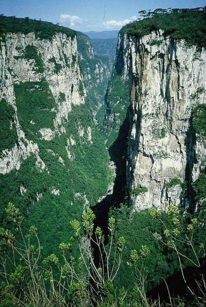
Aparados da Serra NP: Located 117 kilometers northeast of Porto Alegre at 907 meters above sea level, Sao Francisco de Paula is the best place to begin a visit to Aparados da Serra National Park, which is Rio Grande do Sul’s largest natural wonder, although no buses go there and the only access is over an unpaved road. Perhaps its very remoteness has helped preserve the pristine condition of this 12,000 hectare park (founded in 1959), with its unspoiled araucaria forests and plentiful fauna, including tapirs, ocelots and red deer. The park’s name is derived from its sheer cliffs, which are at their most spectacular when viewed from Canyon Itaimbezinho and some of which form fissures in the basalt plateau of up to seven kilometers wide and 700 meters deep.
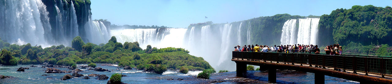
Puerto Alegre: The “cheerful harbor” is the place where most tourists begin their visit to southern Brazil. There are also good air and bus connections from here to Rio and Sao Paulo, as well as to the capital cities of neighboring countries. Porto Alegre is the country’s largest interior harbor, although it is not as busy as it was in the past. The city was founded in 1732 on the eastern bank of the Rio Guaiba by Portuguese immigrants. Ships leaving the harbor find their way to the Atlantic through the nearly 10,000-square-kilometer “Duck Lagoon,” Lagoa dos Palos. Porto Alegre is more than twice as far from the Brazilian capital city of Brasilia (2,100 kilometers) as it is from the neighboring Spanish-speaking capitals of Montevideo (880 kilometers) and Buenos Aires (1,060 kilometers). The city has 1.5 million inhabitants, many of whom are descendants of Italian, German or Polish immigrants. Its buildings reflect the influences of modern architecture.
The entire historic center of Porto AIlegre is concentrated on a small hill called Praga Marechal Deodoro. The enormous Neo-Renaissance dome surmounting the cathedral (which was not completed until 1986) dominates the pleasant church square. Next door to the cathedral stands Palacio Piratini, a neorococo palace containing outstanding wall murals by the Italian painter Aldo Locatelli that was built in 1921 to house the offices of the regional government. At the lower end of the square is the city’s most interesting edifice from an art-historical standpoint, Teatro Sao Pedro, a Portuguese Baroque structure dating from 1858. This theater, which is a national monument, was lovingly restored and modernized in 1984 at the urging of Eva Sopher, a theater enthusiast of German origin.
The Mercado Publico at Praqa XV de Novembro is a busy and colorful market that is open Monday through Saturday. The structure in which it is held is a copy of the renowned Mercado da Figueira in Lisbon.
Sao Leopoldo: Thirty-four kilometers north of Porto Alegre lies the city of Sao Leopoldo, founded in 1824 by a group of German immigrants consisting of farmers and craftsmen, two doctors, a pharmacist, and a Lutheran pastor and his family. Early settlers were welcomed to Sao Leopoldo at the Casa do Imigrante, which is now a museum. The city’s early history is also documented at the Visconde de Sao Leopoldo museum. A must for railroad buffs, the Museu do Trem, is located in the former railway station, which was built by Englishmen in 1875.
Serra Gaucha: In contrast to the pampa (grassy plains) located in the southern part of the state, the Serra Gaucha, which lies to the north of Porto Alegre, consists largely of a high forested plateau. It is part of the southern Brazilian shield, which is made up of two layers. The lower one, comprised of sedimentary stone, is about 250 million years old, while the upper level is basalt, which formed from cooling lava streams some 150 million years ago.
Canela, 140 kilometers northeast of Porto Alegre, is 830 meters above sea level. Winter temperatures sometimes go below freezing, and about every 20 years there is snow, which is a great novelty for Brazilians. Three kilometers to the northwest stands the 42-meter-tall and 2.7meter-diameter Pinheiro multisecular, an araucaria tree that is estimated to be at least 500 years old. This type of conifer was Brazil’s most important source of wood until extensive logging of the Amazon’s forests began in the 1960’s. Other impressive specimens of this tree are at Parque Caracol, a recreational area nine kilometers away and a good place for a day’s outing. It features paths that crisscross an araucaria forest, picnic sites, and Cachoeira do Caracol, a 131-meterhigh cascade.
Eight kilometers to the west, and at the same altitude as Canela, is the town of Gramado, which is famous for its annual film festival in August. A regional (and tasty) attraction you can sample throughout the year is cafe colonial – brunch consisting of home-made sausage, jam, hot chocolate, cake and cheese.
